Where Eiffel and Ardennes meet
East Belgium, meaning all 11 communities, are located in the transnational central mountain range of Ardennes-Eiffel, a geological part of the linksrheinische Schiefergebirge. Here, the western Ardennes meets the eastern Eifel. This ancient central mountain range is a hilly, high country range with expansive forests, which is often divided by deep river valleys (Our, Warche, Amel) or wide, flat, meadow valleys (Göhl, Weser).
This area is crossed by the watershed of Maas and Rhein.
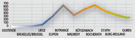
Europes last high moor is located in the center, the High Venn, with peat and moor areas. The highest peak of the area, and also the highest peak of Belgium, is Signal de Botrange in the community of Weismes, at a height of 692.5 m. The lowest point above sea level is located in the community of Lontzen, with 180 m.
Plenty of forests
Eastern Belgium is covered by 40,000 ha (40 km2) of forests. Approximately 20,000 ha range from the High Venn to Eupen and Raeren, the Hertogenwald. To the north is the hilly area of Eupen and the Göhltal with branches of the Herver area and its characteristic hedge landscapes.
In the south, thick forests interchange with meadows and farmland. The ancient central mountain range is divided by many streams and river runs, which have formed narrow and wide valleys.
5000 ha of this landscape are listed as environmental protection areas.
Pure Air
The area is part of the Atlantic climate, with relatively high precipitation and temperate but long winters. The mountain range of Eifel and Ardennes has an exceptionally stimulating climate (higher wind speeds, lower temperatures, larger differences in the daily temperature, faster cooling rates, lower oxygen pressure, and increased UV radiation) and is a pure air area.
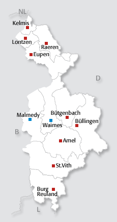
Approximately 91,000 inhabitants in 1000 m2
The total area of the eleven communities is approximately 1052 km². The geographic location: 50° 45 north (+/- 100 m south of the border triangle Belgium The Netherlands Germany) to 50°08 north (1 km south of Ouren in the community Burg Reuland), as well as 5°39 east (Eau Rouge at the Circuit of Francorchamps in the community of Malmedy) to 6°25 east (1.7 km east of Krewinkel in the community of Büllingen). With approximately 91,000 inhabitants, this is a population density of 86.5 inhabitants/km2
The area has no direct border with the Netherlands, even though the northernmost community, Kelmis, is 100 m away from the border triangle. The border with Germany is 161.4 km long, the border with the grand Duchy of Luxemburg an estimated 17 km.